What is happening in Titan’s equatorial belt?
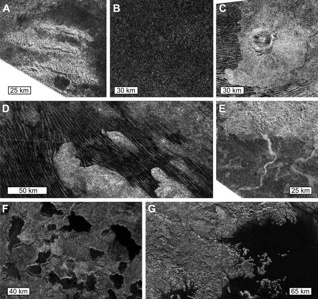
During the last thirteen years (2004 – 2017), the Cassini-Huygens mission allowed a real revolution in the exploration of Titan, the largest moon of Saturn. This mission has revealed that Titan is – in many aspects – very similar to Earth. Titan is a frozen version of Earth, where methane behaves as water, and water ice may be as hard as rock. Despite its strange characteristics, Titan undergoes a rich variety of surface processes that are likewise analogous to those on our planet. Titan being entirely shrouded by a dense atmosphere made of dinitrogen, methane and solid organic particles (i.e. tholins), direct observation of its surface is only possible through radar data, as well as infrared data within specific wavelengths intervals. SAR images from the radar, allowed identifying various landscapes on the moon (see Image 1), and evaluating their global distribution, notably for the lakes and dunes. Lakes are mostly confined around the poles, while the dunes dominate the equatorial belt. Thus, the nature of Titan’s surface major landforms seems quite understood thanks to SAR images, however, it is crucial to determine not only their precise morphology, but also the origin and nature of the material composing or coating the various landscapes to better understand the climatic and geological history of this intriguing moon.

Image 1: A few examples of Titan’s landscapes seen through SAR images, including (A) mountain chains embayed by plains, (B) undifferentiated plains, (C) impact crater, (D) dunes, (E) river channels, (F) small lakes, and (G) a close up of the second largest sea, namely Ligeia Mare. SAR images were acquired during Titan flybys (A, B) T43 in May 2008, (C) T77 in June 2011, (D) T21 in Dec. 2006, (E) T44 in May 2008, (F) T19 in Oct. 2006, and finally (G) T28 in April 2007. Note that Titan flybys are tagged with the abbreviated target name “T” and the flyby number.
Polar lakes are filled with liquid hydrocarbons, whereas the compositions of the other landscapes have not been clearly defined to date. In Brossier et al. (2018) we attempt to retrieve such information and provide new insights on the nature, the origin, and the evolution of the most remarkable landscapes seen at low latitudes, including dunes, mountains, plains and more. For doing that, we applied a newly updated radiative transfer model to the infrared data acquired by the Visual and Infrared Mapping Spectrometer (VIMS) onboard Cassini (Maltagliati et al., 2015) to evaluate the atmospheric effects and to retrieve the contribution of the surface (albedo) for each region of interest. In order to complete the compositional analysis by comparing the surface albedo on Titan with surface candidate compounds, we developed a spectral mixing model and used it to create a vast spectral library of binary mixtures for water ice and tholins, the two major candidates for Titan’s surface composition, with varying mixing ratios and grain sizes. Indeed, water ice is supposed to form Titan’s upper crust (Tobie et al., 2005), while tholins are photochemically produced in the atmosphere and settle on surface over time (Tomasko et al., 2008).
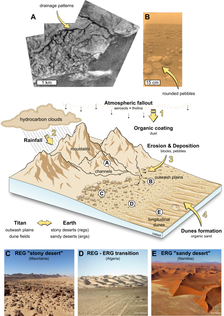
Finally, by putting together our compositional analysis and geomorphological observations, we gave new valuable insights on the formation and evolution of Titan’s equatorial landscapes. The differences in the retrieved composition result from differences in mechanical erosion and grain size sorting by alluvial processes, and mixing by aeolian processes. The atmospheric organic “dust” deposits tend to dominate Titan’s surface, covering mountains and plains. These organics can be transported downward by fluvial processes after rainfalls, and can be then blown by the winds to form the dunes in the lowlands, exactly as on terrestrial transitions areas from mountainous terrains to stony deserts (regs) and sandy deserts (ergs) (see Image 2). Thus, through this investigation we show that Titan’s low latitudes undergo geological processes very similar to those occurring in arid regions on Earth, in agreement with the predictions of climate models for Titan.

Image 2: Cartoon model displays a typical transition from the highlands (mountainous terrains and crater rims) to the lowlands (outwash plains and dune fields) on Titan’s equatorial belt. This transition implies similar landscapes than those seen in terrestrial deserts, except that sedimentary materials on Titan are organics derived from atmospheric fallout and water ice grains from the substratum. Picture (A) displays fluvial networks identified by Huygens’s imager during its descent toward the surface (January 14, 2005), while (B) is a picture of the surface acquired by the probe after its soft-landing (Tomasko et al., 2005). Pictures (C) to (E) illustrate terrestrial transition areas analogous to the terrains investigated in Brossier et al. (2018): (C) is a stony desert also called reg, and (E) is a sandy desert also called erg. Courtesies from (C) Ji-Elle, (D) P-A Bourque, and (E) M. Poliza.
Article
Brossier, J. F., Rodriguez, S., Cornet, T., Lucas, A., Radebaugh, J., Maltagliati, L. et al. (2018). Geological evolution of Titan’s equatorial regions: Possible nature and origin of the dune material. Journal of Geophysical Research (Planets). 123. DOI: 10.1029/2017JE005399.
First published: 17 avril 2018
Author
Post contributed by Jeremy Brossier, Deutsches Zentrum für Luft- und Raumfahrt (DLR), Institute of Planetary Research, Berlin, Germany. Main collaboration with Sébastien Rodriguez and the Planetary and Space Science group of the Institut de Physique du Globe de Paris (USPC – Université Paris 7-Paris Diderot/CNRS).
My ResearchGate: https://www.researchgate.net/profile/Jeremy_Brossier
Further Reading
- Brossier, J. F., Rodriguez, S., Cornet, T., Lucas, A., Radebaugh, J., Maltagliati, L. et al. (2018). Geological evolution of Titan’s equatorial regions: Possible nature and origin of the dune material. Journal of Geophysical Research (Planets). 123. DOI: 10.1029/2017JE005399.
- Maltagliati, L., Rodriguez, S., Sotin, C., Cornet, T., Rannou, P., Le Mouélic, S. et al. (2015). Simultaneous mapping of Titan’s surface albedo and aerosol opacity from Cassini/VIMS massive inversion. 10th EPSC Abstracts.
- Tobie, G., Grasset, O., Lunine, J. I., Mocquet, A. and Sotin, C. (2005). Titan’s internal structure inferred from a coupled thermal-orbital model. Icarus, 175. 496 – 502. DOI: 10.1016/j.icarus.2004.12.007.
- Tomasko, M. G., Archinal, B., Becker, T., Bézard, B., Bushroe, M., Combes, M. et al. (2005). Rain, winds and haze during the Huygens probe’s descent to Titan’s surface. Nature, 438, 765 – 778. DOI: 10.1038/nature0426.
- Tomasko, M. G., Doose, L., Engel, S., Dafoe, L. E., West, R., Lemmon, M. et al. (2008). A model of Titan’s aerosols based on measurements made inside the atmosphere. Planetary and Space Science, 56, 669 – 707. DOI: 10.1016/j.pss.2007.11.019.
