I12 Multi-wavelength & Multi-Physics Planetary Peeling
The project has been closed on 2017 by the work package leader.
.
-
Solar System exploration unveiled the ubiquity of mass wasting. The project aims at combining data analysis with model simulation at various scales and wavelengths, thereby allowing a quantitative assessment of the geomorphology across a wide range of planetary environments. It will help to inform geomechanical models applied to mass wasting in surface and sub-surface properties, as well as various triggering and feedback mechanisms operating throughout the Solar System. Ultimately, this project will provide new understanding on how planetary surfaces form and evolve over time, from small bodies to icy moons and planets.
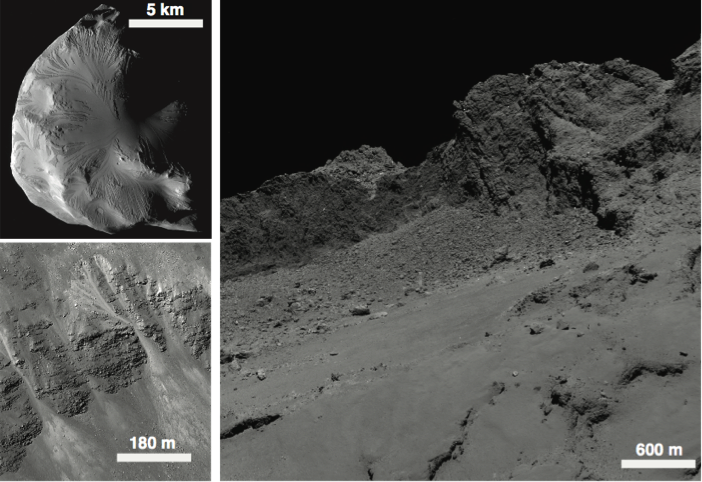
Figure 1 – Mass wasting in the Solar System: (Top-left) Helen, (bottom-left) the Moon and (right) 67P/Tchourioumov-Guérassimenko
The WP is divided in three main tasks
Task #1: Photometry of Vesta’s mass wasting from high precision astrometry
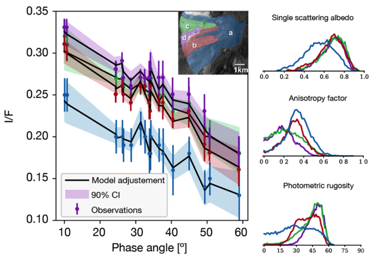
During its one-year orbital mission, the NASA/Dawn probe mapped the surface of Vesta, on of the brightest object in the Asteroid Belt. Features, such as craters, avalanches, cliffs and fresh ejectas, with unexpected and unexplained brightness are observed over various phase angles. In order to understand these brightness variations in terms of physical properties of the soil at millimeter depth, we aim at using a photometric model coupled with a Monte Carlo and Bayesian inversion approach (Figure 2). This has been applied first to the Cornelia crater about the equator of Vesta where many of these variations are visible, most probably due to mass wasting uncovering less mature terrains.

Figure 2 – Photometric modeling of mass wasting deposits on Vesta using Bayesian inference on Hapke model.
Given the observing geometries provided for this crater, only the single scattering albedo, roughness and the shape of the scattering lobe of the different avalanches are satisfactorily determined. Due to lack of data at very low phase angles, the CBOE is not constrained. Also the relative weight of the backscattering component, the porosity P and Hapke parameter of the SHOE B0 are not constrained by observations confined at phase angles below 80°. All Cornelia avalanches have a tendency to scatter forward in a rather anisotropic way whereas it is undetermined for the Matronalia Rupes areas, due to insufficient data. Almost all of seven features (except one) share a quite similar photometric roughness where it could be expected to be much more various due to their diverse morphology.
Temperatures and their diurnal variations dependent also on the soil structure at somewhat larger depth, from cm-to-dm, in particular the grain size or the porosity and Bond albedo of the regolith. We have been starting to gather temperatures of the crater walls from their thermal emission above 4.5 um as observed by the VIR spectrometer. In order to compare observed and expected temperatures as a function of solar incidence angle (and local time), we are being coupling the Vesta digital elevation model (DEM) with a version of the Ferrari and Lucas model (2016) adapted to rocky Vesta material. Physical properties of the different zones of avalanches as determined from the diurnal cycle will be compared to the superficial photometric data and further discussed.
Along with this remote-sensing approach, geomechanical modelling will start at fall 2017 and will take benefit from the constraints discussed previously.
Highlight: A paper in under progress and is expected to submitted by Fall 2017.
Acknowledgment: This work has done in the framework of Master internship of Amande Roque-Bernard under the guidance of Antoine Lucas and Cécile Ferrari. We thank the UnivEarthS LabEx and CNES for their support on this task.
Task #2: Mass wasting importance for Titan’s landscape dynamics
The landscapes of Titan were observed for nearly 13 years by the Cassini spacecraft and Huygens probe. With dunes, mountains, seas, lakes, rivers…, the great morphological variety observed testifies to the geological richness that Titan shares with the Earth.
The largest moon of Saturn, Titan, presents unique characteristics in the Solar System : first, its huge size (larger than Mercury), a rich and dense atmosphere mostly composed of methane and dinitrogen are factors to consider, but an uncommon aspect is the presence of hydrocarbons in a liquid state. Lakes, rivers and other surprisingly familiar Earth-like landscapes (dunes, mountains) have been observed by the Cassini probe sensors (namely the VIMS camera, and the RADAR imager). These geological structures bear witness to a little-known geological activity of Titan.
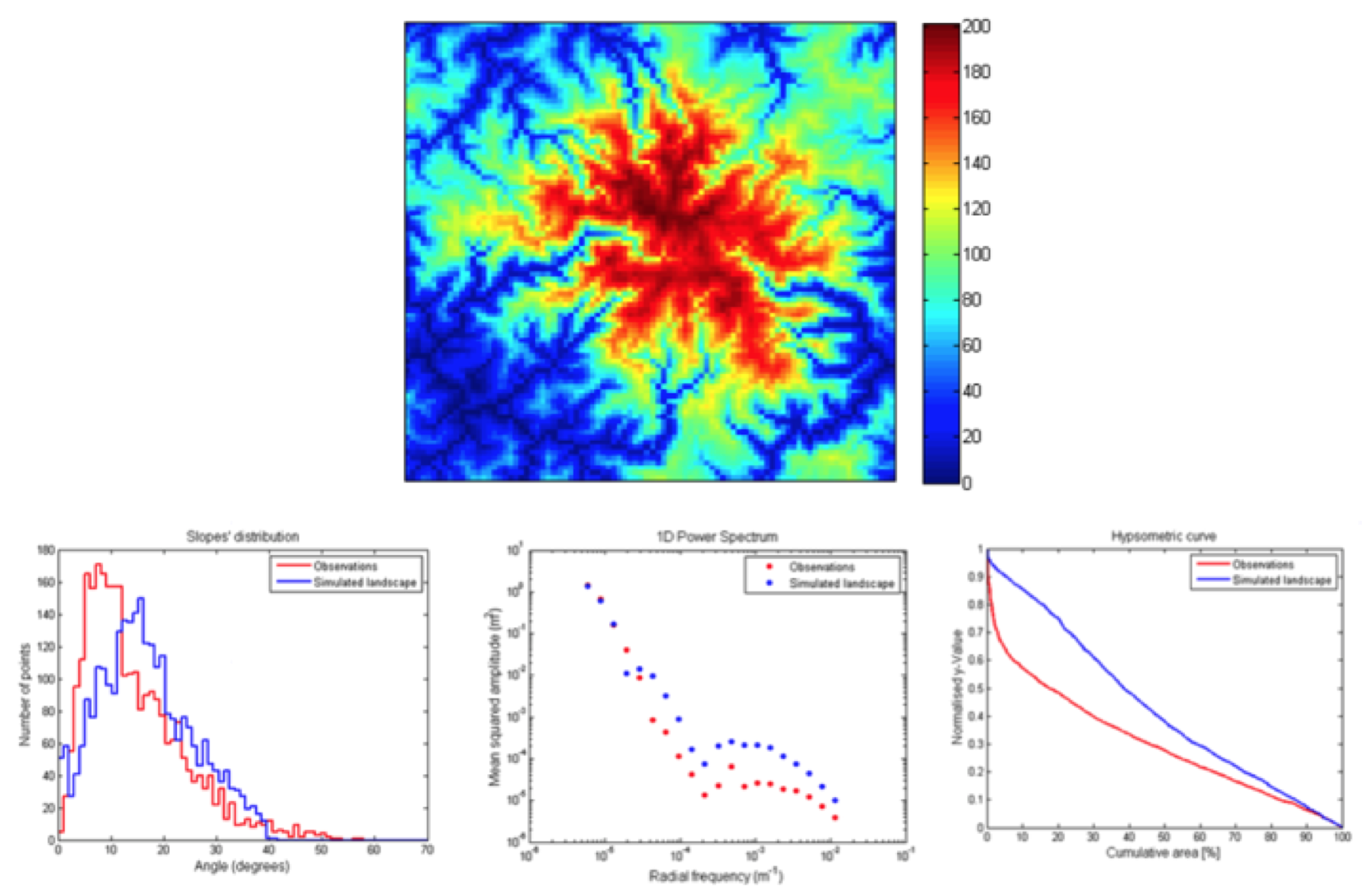
In order to understand the mechanisms of these landscapes formation, and their bounds to the local climate, a model of the landscape evolution has been developed. It was calibrated for Titan, in particular, for the landing site of the Huygens probe, surrounded by mountains eroded by rivers and mass wasting. In this study, we combine analysis of radar and hyperspectral data provided by the Cassini-Huygens mission, with models of valley and river network evolution to better understand the processes at work that sculpt these familiar landscapes.

Figure 3 – Timescale and incision rate assessed from landscape dynamics modelling accounting for Titan’s surface conditions.
We develop quantitative criteria for comparing 3D morphologies obtained by the numerical simulations with those derived for Titan by photogrammetry. These criteria are validated on Earth’s landscapes. We simulate morphologies similar to those observed and show that landscapes at the equator and poles are mainly controlled by river incision and mass wasting such as landslides for which we quantify their respective contribution and their main characteristics (namely, incision rate and critical slope, respectively).
Subsequently, we relate modeling to precipitation rates of methane and show values that are to be compared with general circulation model predictions (GCM). Our results also show a very young age of formation of the observed morphologies, less than a few million years. Finally, we provide new constraints on current amplitude of the tidal effects and organic precipitation rates from atmosphere chemistry.
Highlight: This work will be presented at the coming AGU Fall Meeting 2017.
Acknowledgment: This work has done in the framework of Master internship of Chloé Daudon under the guidance of Antoine Lucas and Sébastien Rodriguez in collaboration with Taylor Perron (MIT). PI thanks the UnivEarthS LabEx, IPGP, the CNES and the Nvidia corporation through the Academic Support Program for their respective support on this task.
Task #3: Photogrammetry from historical aerial imagery: application to mass wasting in tropical island
We aim at better understanding erosion processes and sediment transport observed in tropical areas on the short period. Indeed, weathering processes regulate the chemical composition of the upper continental crust, and at geological time scale weathering also regulates the CO2 concentration in the atmosphere via weathering‐climate feedback. Particularly, the research conducted during this task focus on processes such as the relationships between climatic events, large scale landslides and torrential transport of sediment by the river in La Reunion Island. Additionally, understanding such processes could also help to prevent related natural hazards. Assessing sediment transport requires the quantification of the sediment volumes involved. This can be done by analysing the evolution of the topography at different periods.
To do so, we develop an automatic photogrammetric workflow allowing to derive digiral topography models (DTM) out of historical aerial photographs. Thereby we can observe the evolution of the river bed and get information about the dynamics of the sediment transfer from the production areas (steep slopes) to the ocean. The tool has been tested with aerial images over the Rempart river (Reunion Island) ranging between 1978 and 2003. Ongoing tests show that the workflow can generate digital models of elevation with an accuracy of roughly 1 meter (Figure 4) but many areas are not derived due to low radiometry dynamics (Figure 4).
Further investigations will be carried out for improving our technique. Sediment transport assessment will be done by winter 2018.
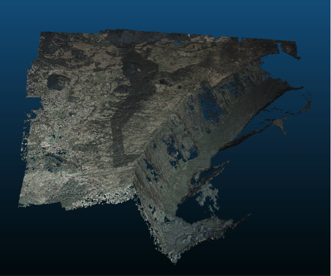
Figure 4 – 3D cloud of Rempart valley at Reunion Island obtained from historical aerial images, offering a sub-metric spatial resolution over a 30 years timeframe.
Highlight: This work will be presented at the coming AGU Fall Meeting 2017 and a paper is under progress with an expecting submission for the winter 2018.
Acknowledgment: This work has been done in the framework of Adrien Sy internship co-supervised by Éric Gayer and Antoine Lucas. A new Ph.D. student (Mathilde Banjan) will pursue this tremendous work.
-
POSITION NAME SURNAME LABORATORY NAME GRADE, EMPLOYER WP leader Antoine LUCAS IPGP (G2E-PSS) CR, CNRS WP co-leader Cécile FERRARI IPGP (PSS) Prof., Paris-Diderot WP co-leader Sébastien RODRIGUEZ IPGP (PSS) McF., Paris-Diderot WP co-leader Stéphane JACQUEMOUD IPGP (PSS) Prof. Paris-Diderot WP member Éric GAYER IPGP (G2E) McF., Paris-Diderot WP member Éric PANTIN AIM (LADP) CEA WP member Chloé DAUDON IPGP (PSS) PhD. Student, IPGP WP member Aurélien BABLET IPGP (PSS) PhD. Student, ONERA -
PUBLICATIONS AND BOOKS
Two papers are under progress and should be submitted by Dec. 2017
CONFERENCE AND WORKSHOPS (PRESENTATIONS AND/OR ORGANISATIONS)
2 presentations at the coming AGU Fall Meeting 2017
TEACHING AND EXTENSION TO THE GENERAL PUBLIC
Outreach communication at “Fete de la science” 2017